Rick Gordon’s Weather Watch
Follow our YouTube channel here.
Today’s Weather
Our white Christmas will start with morning clouds, followed by some afternoon sunshine and a breezy feel. The high will be around 37 degrees, feeling more like 32, with west-northwest winds at 15 to 25 mph with gusts to 35 mph.
Snow Totals + More to Come
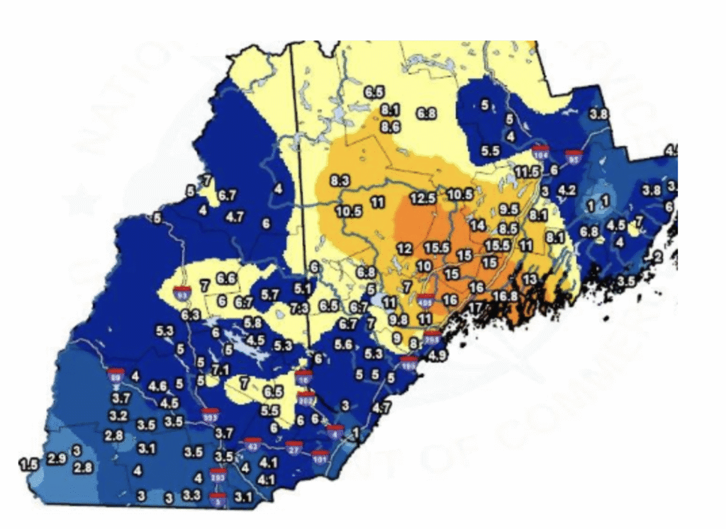
A strong cold front is set to arrive on Christmas Day, bringing a sharp drop in temperatures by evening. Friday will be bitterly cold, with the wind making it feel even chillier. While temperatures are expected to slowly climb by Sunday, there’s also a chance for more wintry weather. Sunday night’s forecast calls for snow, a mix of snow and rain, or icy conditions, which could make post-holiday travel a bit challenging. Some snowfall totals from the most recent storm.
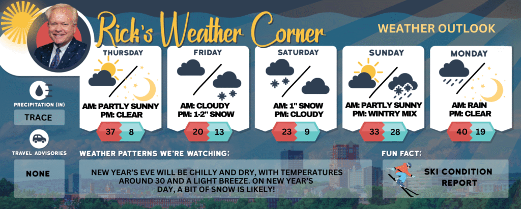
Tonight: Partly cloudy, breezy, & frigid. Low 8 (feel like -7) Winds: NNW 15-25+ mph
Friday: Clouding up and very cold. High Around 20 (feel like 10) Winds: NNW 5-10 mph
Friday night: Some snow (1-2″). Low 13 Winds: Light & Variable
Saturday: Light morning snow of about an inch, followed by mostly cloudy and cold conditions. High 23 Winds: Light & Variable
Saturday night: Becoming clear & frigid. Low 9 Winds: Light & Variable
Sunday: Not as cold with morning sun with afternoon clouds. High 33 Winds: WSW 5-10 mph
Sunday night: Wintry mix with about an inch of snow and ice. Low 28 Winds: Light & Variable
Monday: Some rain (.20″), breezy, and not as cold. High Around 40 (feel like 30) Winds: W 10-20 mph
Monday night: Some clearing & colder. Low 19 (feel like 9) Winds: W 10-15 mph
Weather Patterns We’re Watching
New Year’s Eve will be chilly and dry, with temperatures around 30 and a light breeze. On New Year’s Day, a bit of snow is likely!
Get Out!
Elevations for summits above 4,000 feet in Northern New Hampshire today: Summits will be hidden with snow likely in the morning, followed by a chance of afternoon snow showers, possibly heavy at times. Highs will range from 12 to 22 degrees. West winds around 35 mph will shift northwest and increase to about 55 mph in the afternoon. Above 5,000 feet, winds will start near 55 mph, turn northwest, and rise to around 70 mph, with gusts up to 100 mph. There’s a 70 percent chance of snow, and wind chills could drop as low as 41 below.
Elevations between 2,500 and 4,000 feet in Northern New Hampshire today: Summits will be hidden with snow likely in the morning, followed by a chance of snow showers in the afternoon, possibly heavy at times. Highs will be in the lower 20s, with west winds around 25 mph shifting to the northwest and picking up to around 40 mph later. Gusts could reach up to 80 mph, with a 70 percent chance of snow and wind chills dropping as low as 24 below.